Mineral exploration is fundamentally a decision process that approaches the underground reality through incomplete information. Outcrops, geochemical and geophysical anomalies, remote-sensing features, drilling data and historical reports provide different windows into the subsurface, but they rarely point naturally to the same conclusion. In deep, covered and structurally complex settings in particular, the real difficulty is not obtaining more data. It is deciding which evidence is trustworthy, how different evidence constrains one another, and whether the next task can reduce the uncertainty that matters most.
AI is changing the speed and scale of information processing in this process, but it cannot remove the complexity of geological objects or replace field verification and professional responsibility. Its value should appear in faster organization of multisource material, clearer recognition of evidence relationships, the formation of testable subsurface hypotheses, and help in directing limited budgets toward the steps most capable of changing a decision. Seen this way, the answer to “Will AI replace geologists?” is not found in a contest between people and machines. It lies in whether they can improve the reliability of exploration judgment together—and that is the starting point for what follows.
01Mineral Exploration Has Never Had a Standard Answer
“Will AI replace geologists?” has been one of the most discussed—and most easily misframed—questions in mineral exploration in recent years. It creates an apparently fierce opposition: field experience, regional understanding and long accumulation on one side; algorithms, computing power and constantly refreshed colour probability maps on the other. But if a high-probability zone identified by AI conflicts with geological understanding, which should be trusted? If a drill hole misses mineralization, is it a failure, or has it eliminated a costly incorrect model?
The “war” between geologists and AI was never very real. The true competition is not over who can produce a final answer in one attempt. It is over who can formulate a subsurface hypothesis worth testing more quickly, discover where it may be wrong earlier, and complete the next round of judgment with less ineffective work.
A geologist’s judgment depends on the available data, personal experience, deposit models and the interpretation of that evidence. Different experts can develop different mineralization interpretations from the same geological, geophysical and geochemical materials. AI is no different: its output depends on which data entered the system, whether they are reliable, where the training samples came from, which constraints the model uses, and how developers define “mineral prospectivity.”
People are affected by experiential pathways, organizational pressure and sunk costs. AI may amplify data bias, fail outside its training distribution, and even classify ordinary weathering, non-mineralizing structures or data-processing artefacts as exploration anomalies. Neither suddenly possesses the complete truth about the subsurface. The difference is that human errors are often hidden in experience and narrative, while model errors may hide in parameters, samples and a heat map that appears extremely certain.
A genuinely professional AI exploration system should therefore not declare “there is definitely ore here.” It should help the team answer more valuable questions: why should this area be prioritized? Which evidence supports the judgment? Which data conflict with it? What is the greatest current uncertainty? How can the next geological task test or reject the hypothesis most effectively?
02AI Changes the Sequence of Exploration
Traditional exploration often follows a path of broad coverage and progressive elimination: regional investigation first, followed by geochemistry, geophysics, trenching and drilling, with the area narrowing as evidence accumulates. The method is reliable, but on large, deeply covered and data-sparse projects, time and money can be spread evenly across areas with very different value. AI moves part of the screening process forward.
Take the workflow published by GAIA Exploration. The system is not an isolated “deposit prediction model.” It connects multisource data, geological constraints, model-based reasoning and field verification: it accesses remote sensing, geological maps, DEM, geophysics, geochemistry, drilling, historical reports and mine data; establishes constraints from regional structure, magmatic activity, hydrothermal systems and deposit models; creates mineral-prospectivity fields through pattern recognition, representation learning, spatial modelling and model ensembles; formulates testable subsurface hypotheses for deep mineralization centres, fluid pathways and concealed orebodies; then validates them through sampling, geophysics, trenching and drilling, returning both successful and failed results to the model.
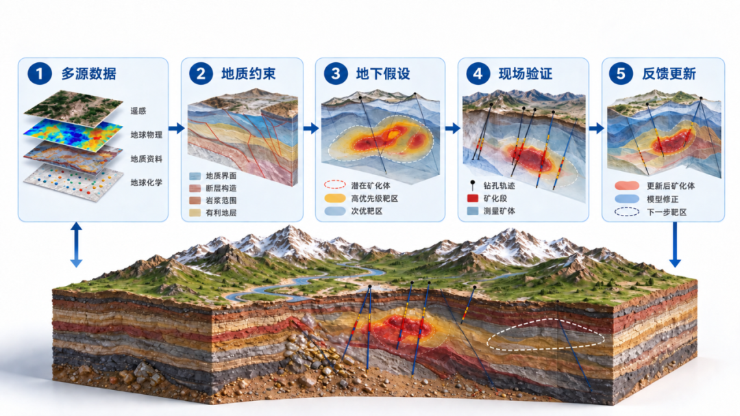
AI does not skip geological work. It changes the order in which budgets are invested: first use AI to narrow the problem; then concentrate geological work on validation; finally let engineering evidence determine whether further investment is justified.
In GAIA’s published case involving an approximately 199 km² concession in Laos, AI first delineated priority zones separately for gold, copper, lead and zinc, then compared them with geochemical anomalies later obtained by the project owner. Some targets showed reasonable agreement in location and trend with multielement anomalies including arsenic, antimony and mercury. But this agreement only indicates that the relevant areas deserve priority work. It does not prove that an orebody has been found, and it cannot replace resource estimation. Geological mapping, infill sampling, geophysics, trenching and drilling remain indispensable.
This is the most accurate scale for the value of AI exploration: it does not declare victory. It helps the team know earlier where to go first—and which idea may not deserve more money.
03From Predicting Mineral Locations to Managing Hypotheses
Early AI exploration products often compressed their final result into a mineral-prospectivity map. Today the industry is moving from point prediction toward geological constraints, multimodal fusion and closed-loop decisions. One clear trend is that systems are no longer forced to select a single interpretation too early.
The same gravity high may come from a dense intrusion or from basement relief. A deep low-resistivity body may relate to hydrothermal fluid, or it may be caused by a conductive medium such as graphite. Even perfectly measured single-source data can support the wrong geological interpretation. A more reliable approach retains several competing hypotheses and tests them against gravity, magnetics, seismic, electromagnetic, geochemical and drilling results.
In such a system, a large language model should not “guess where the ore is.” It is better suited to organizing information and extracting constraints: structural, age, lithological and petrophysical information from historical reports, papers and maps, with the source and confidence recorded before specialist models and geologists make judgments.
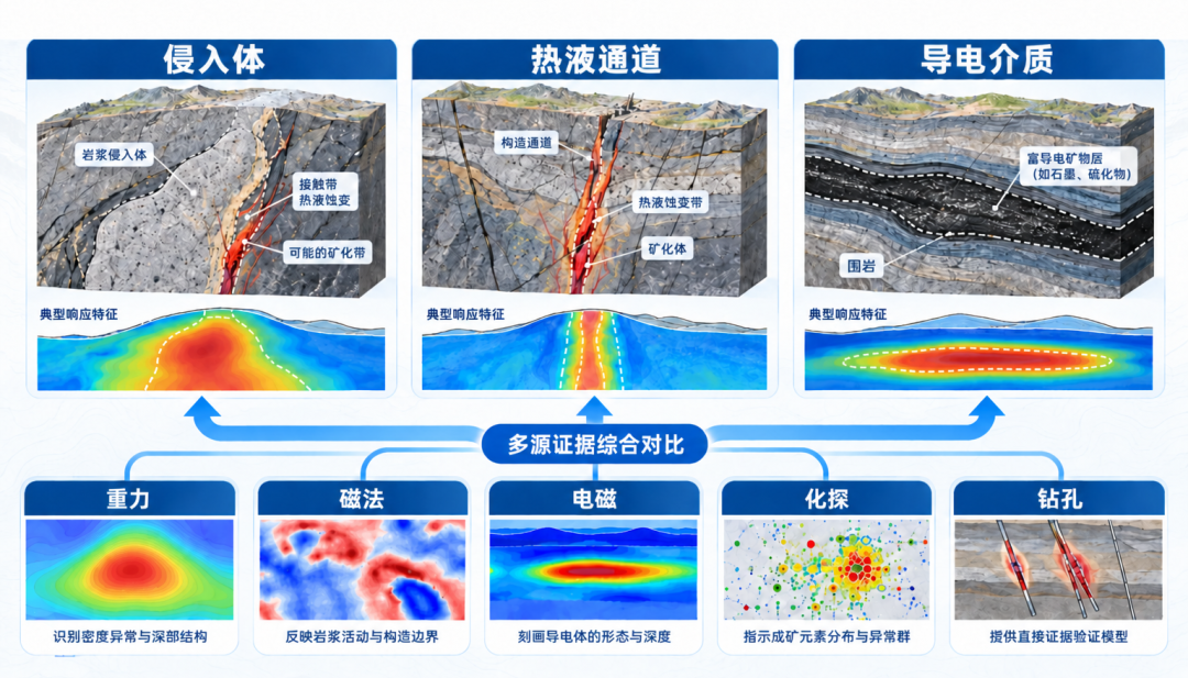
When evidence is insufficient, the system should preserve broad uncertainty rather than inventing a precise dip from a “near-vertical fault” or converting “possible deep alteration” into a definite resistivity merely to produce an attractive answer. AI is advanced not because it appears certain, but because it knows where it is uncertain.
04Bringing AI into Real Geological Workflows
What deserves attention at GAIA is not only an algorithm, but its “AI + HI” path: artificial intelligence takes on intensive information processing, task execution and evidence organization, while geologists retain control over geological interpretation, validation programmes and engineering decisions. Its published technical system covers mineral-system modelling, geological representation learning, deep mineral-system reasoning, four-dimensional geological inversion, drilling optimization and field feedback.
In September 2026, GAIA launched the Gaia Geoscience Agent Platform. It does not simply add a chat window beside traditional software, and it does not attempt to make one “universal AI” handle every geological problem. It organizes specialist agents, project data, models, tools and continuous workflows in one project environment around real tasks. Geologists define the problem and professional boundaries; agents understand the task, call data and tools, and complete multistep analysis; geologists then review the result and make the judgment.
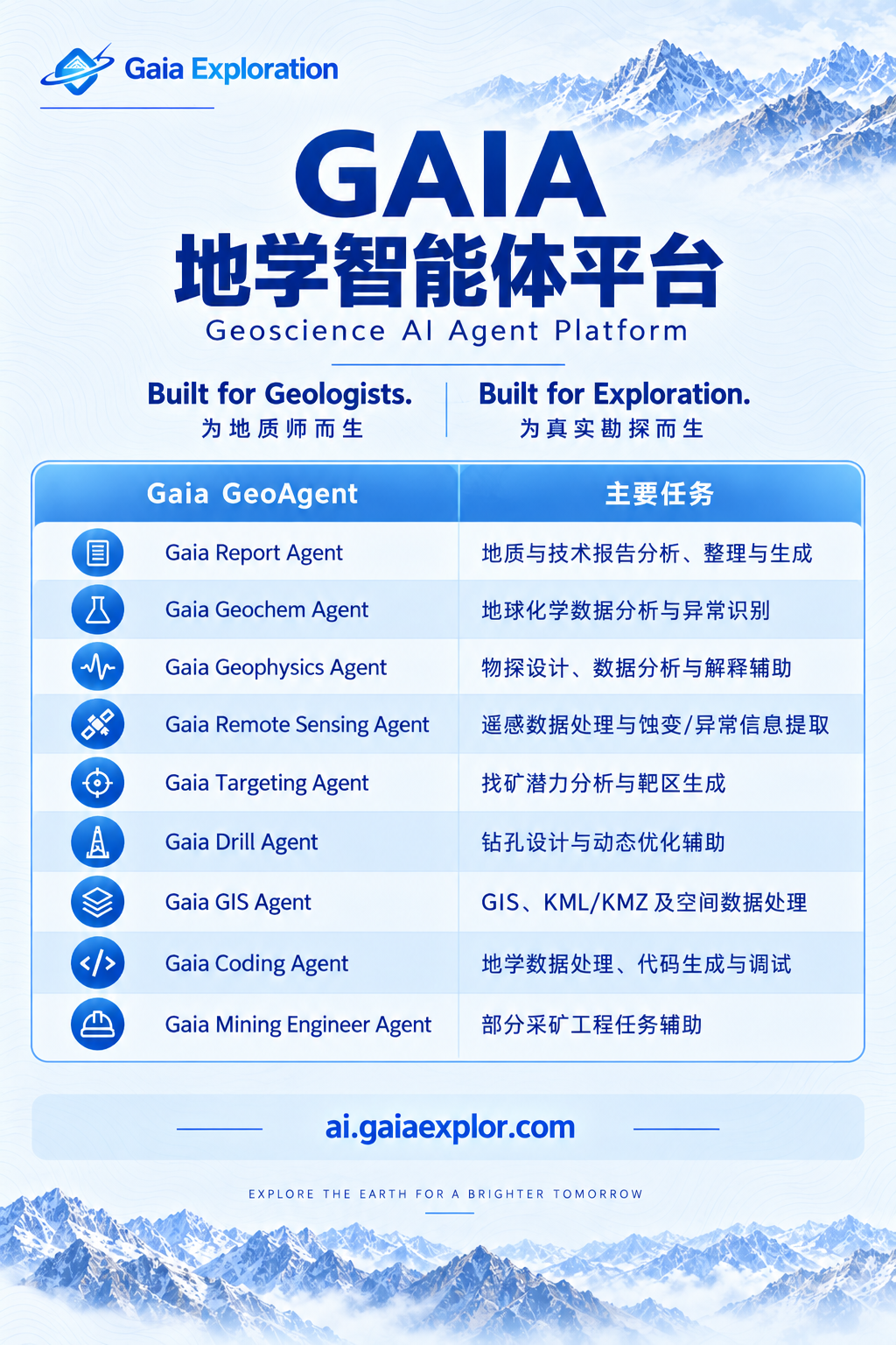

The platform serves mining companies, mineral-exploration and development teams, geological surveys and technical-service organizations, as well as professionals who need to process large volumes of heterogeneous geoscience information. GAIA configures different specialist GeoAgents for technical reports, geochemistry, geophysics, remote sensing, GIS spatial analysis, exploration targets, drilling and data processing. They can first organize historical reports and evidence sources, then process geochemical, geophysical and remote-sensing data, compare candidate targets, organize spatial results, and return new reconnaissance, sampling or drilling results to the next analytical cycle.
For geologists, the platform is intended to reduce not professional judgment, but the time spent repeatedly importing files, standardizing formats, searching materials, redrawing maps and moving context among software tools. It aims to strengthen evidence traceability, conflict recognition, expression of uncertainty and validation-programme design. Each conclusion should return as far as possible to the source report, page, figure, sample, drill hole and model version so that “why this judgment was reached” can be reviewed.
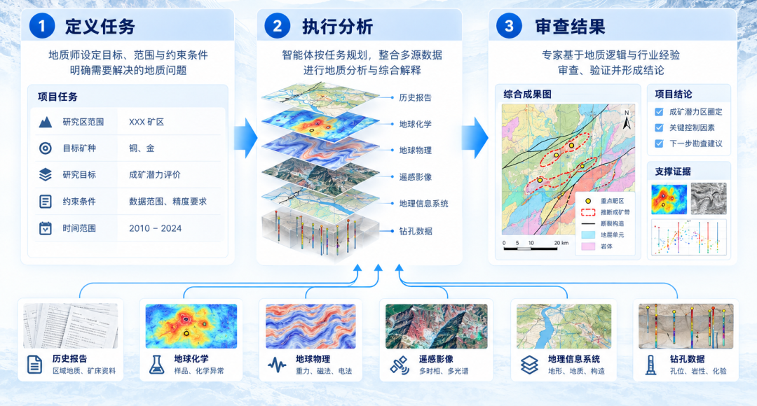
This explains why GAIA emphasizes bringing AI into real geological workflows. Report analysis cannot stop at text summaries, and geochemical or remote-sensing results should not end as one-off maps. Only when different specialist agents collaborate continuously in the same project context can AI move from a demonstration tool to a production tool geologists can genuinely use.
GAIA’s cooperation models are not limited to software subscriptions. Public materials also describe project-based technical services, success sharing and Earn-in structures, through which technology, capital or exploration capability participates in value creation by stages. The company has a registered technical entity in Singapore and R&D and operating operations in Chengdu, and publicly lists offices or regional headquarters in Beijing, Jakarta, Tanzania and Kazakhstan. Its project network includes Indonesia, Laos, Zimbabwe, Mozambique, Tanzania and several Central Asian countries.
From a long-term project perspective, these models can create a cycle among technology, project data and resource interests, but they also raise disclosure requirements. Mineral-title ownership, equity percentages, historical investment, community relations, environmental responsibility and exit conditions cannot be replaced by a technical narrative about “AI exploration.” The deeper professional capability enters a project, the clearer the boundaries of responsibility must become.
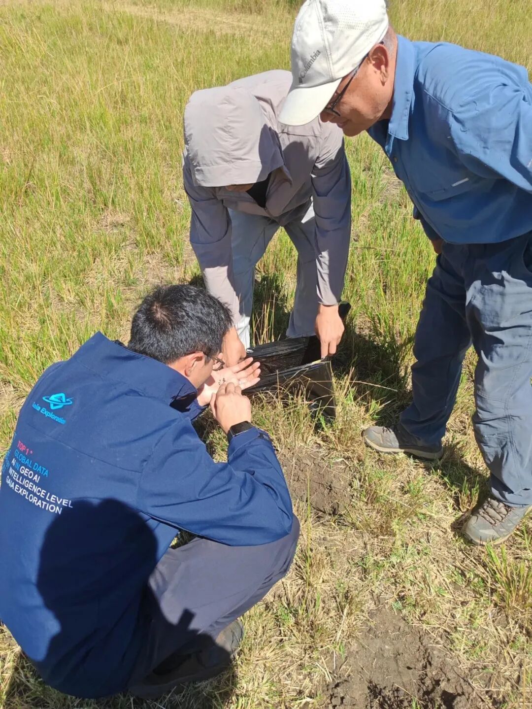
The Most Valuable Hole May Not Intersect an Orebody
Another direction for AI exploration is a shift from “where is mineralization most likely?” to “how can the next hole obtain the most information?” In deep, covered and structurally complex environments, the true subsurface state cannot be observed directly. Project teams usually face not a known orebody, but several geological models that have not yet been confirmed.
Bayesian updating, partially observable Markov decision processes and related methods can treat drilling as a sequence of decisions. Every hole adds lithology, alteration, grade and thickness information, after which the credibility of different hypotheses is updated and the location and sequence of the next hole can be chosen.
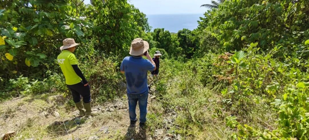
A hole that does not intersect ore can therefore still be highly valuable. If it rejects an incorrect mineralization model, it may prevent ten or more later holes from being wasted. True drilling optimization does not simply promise “fewer holes.” It gives every hole an explicit falsification task.
The International Energy Agency’s 2025 critical-minerals outlook likewise considers AI geological exploration to have the potential to reduce drilling costs and improve discovery success. But “potential” is not an industry-wide guarantee. It still needs to be demonstrated through blind testing, backtesting, independent data and actual drilling results.
06Geological Judgment Will Move toward Higher-Value Work
AI can read information faster, standardize formats, discover relationships across datasets, and repeatedly perform calculations and comparisons people do not want to repeat. But it cannot assume a geologist’s most important responsibilities: deciding whether data deserve trust; recognizing when a model violates mineralization mechanisms; distinguishing anomalies, mineralization, orebodies and economic resources; designing fieldwork that can genuinely falsify a hypothesis; and deciding to pause when evidence is insufficient instead of continuing to search for reasons to support an existing narrative.
The more likely future is not the disappearance of geologists, but a change in the division of work. Low-value transfer of materials, format conversion, repetitive map production and preliminary screening will be automated further. Understanding mineral systems, judging conflicts in evidence, designing field validation, communicating resource risk and making capital decisions will become more important.
AI will not make professional judgment less important. On the contrary, as information-processing costs fall, the scarce capabilities will be asking the right questions, identifying incorrect models and accepting responsibility for the final judgment.
07The Real Divide Is Whether a Closed Loop Exists
To judge whether an AI exploration system is worth using, do not look only at model parameters, interface appearance or the number of targets it generates. Ask: where did the data come from, and were they governed? Can the geological logic behind the targets be explained? Are predictions, inferences and verified facts clearly distinguished? Does the system show uncertainty and disconfirming evidence? Can field results enter the next model update? Does the project have rules for stopping, restructuring and exiting?
Only a system that can answer these questions has a chance to move from demonstration to production. The real relationship between geologists and AI is therefore not about which obeys the other, but about which makes the other more reliable.
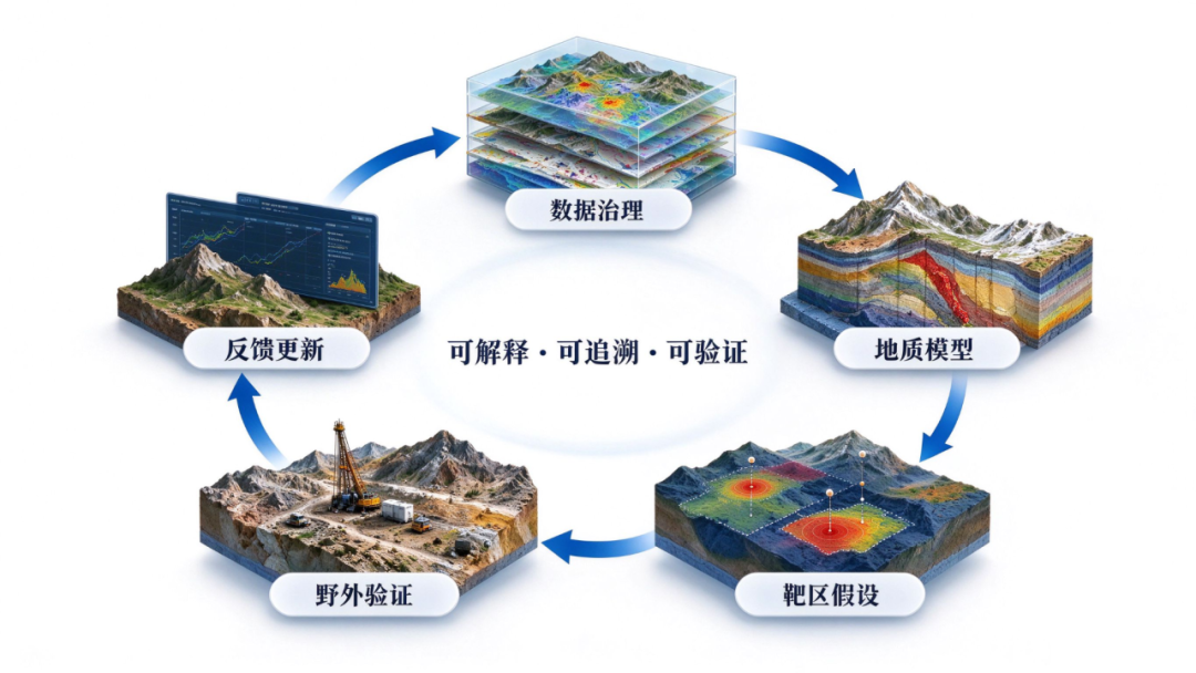
Geologists provide AI with mineralization mechanisms, professional boundaries and tests against reality. AI helps geologists process more information, retain competing interpretations, expose cognitive blind spots, and invest limited budgets in the next step most capable of changing the decision. The future winners will be neither geological teams that reject AI nor algorithm companies that try to bypass geology. They will be those able to connect data, models, expert judgment, field validation and capital discipline in a closed loop.
Because in mineral exploration, the most expensive problem is never having no answer. It is believing a wrong answer too early.
ConclusionGeologists Are Not Leaving
AI entering mineral exploration does not mean geology is leaving. It means the relationship among information processing, hypothesis formation and validation decisions is being reorganized. Technology can read materials, connect data and compare programmes more quickly, but it cannot replace understanding of mineral systems or assume the project team’s final engineering responsibility. Reliable intelligent exploration must always return model outputs to geological logic and field evidence for testing.
GAIA aims to advance precisely this explainable, traceable and verifiable form of human–machine collaboration: let the Gaia Geoscience Agent Platform take on more repetitive and intensive information processing and task execution, while geologists focus on critical interpretations, conflicts in evidence and the next validation step. In the future, exploration efficiency will not be determined by the single choice of “whether to use AI,” but by who can truly connect data, models, expert judgment and field feedback in a closed loop. Geologists will not be replaced by AI—but the era of exploration by experience alone is coming to an end.