One of the most frequent questions in mineral exploration is straightforward: Leapfrog, Surpac, Datamine and Vulcan are already mature, so what remains for AI to do?
The question identifies the real boundary. Over the past two or three decades, geological software has transformed data management, 3D modelling, resource estimation and engineering expression. Drill data can be managed rapidly, faults and stratigraphy modelled in three dimensions, bodies updated dynamically, grades estimated with variograms and kriging, and geophysical datasets forward-modelled or inverted with established tools.
Traditional software and exploration AI, however, solve different problems. The former calculates and expresses a geological understanding that has already been formed. The more valuable role for AI is upstream, before that understanding has stabilized, where evidence is fragmented, anomalies are weak and multiple explanations remain possible.
The central question is not whether AI replaces Leapfrog. It is whether AI helps a geologist formulate, compare and test hypotheses more systematically.
Geological computation is mature; judgment remains the bottleneck
Exploration work can be considered in five layers: data management, numerical calculation, 3D representation, integrated interpretation and exploration decision. Traditional software is exceptionally strong in the first three. Implicit modelling with radial basis functions can build continuous geological volumes from holes, contacts and faults. Variography, ordinary and simple kriging, inverse-distance weighting, nearest-neighbour estimates, conditional simulation and block models form the foundation of modern resource work.
These tools answer how to build a model faster and more accurately. They do not by themselves answer why the model should be believed.
Before modelling, a team may face scattered, weak and contradictory observations: As-Sb-Hg anomalies, slightly elevated Mo and Bi, a concealed fault, local phyllic alteration, offsets between magnetic and geochemical centres, and unusual trace-element signatures in pyrite. Software can display each layer, but the decisive judgment is whether they share a cause or reflect unrelated processes. Exploration AI has the potential to assist this transition from multisource evidence to geological explanation.
Weak-signal combinations change anomaly recognition
Strong Au, Cu, As or Sb anomalies clearly deserve attention, but covered and deep systems often present a different problem. No single indicator is dramatic; significance lies in several weak signals appearing in a particular spatial relationship.
W, Mo and Bi may be only slightly elevated. If they cluster near an ore-controlling fault and coincide with a changing K/Rb ratio, a Co/Ni shift in pyrite, diagnostic alteration minerals, a magnetic gradient and a distal As-Sb-Hg volatile halo, the question is no longer whether one element is “high.” It is whether the multivariable association makes geological sense in that structural setting.
Machine learning should not amplify ordinary background into a discovery. Its legitimate role is to identify stable, explainable and testable associations among weak signals. AI can point out which subtle observations may collectively deserve verification because they share a fault, lithology, alteration front or fluid pathway.
From geometric distance to geological pathways
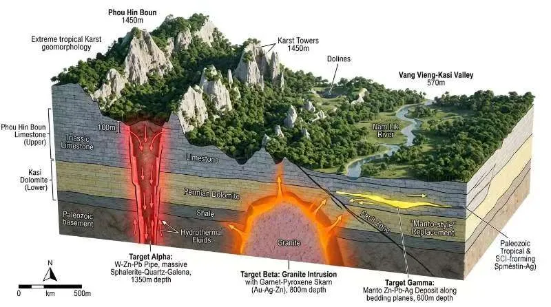
Spatial statistics rightly emphasizes distance, continuity and variograms. Hydrothermal fluids, however, do not necessarily travel along the shortest straight line. They follow faults, fractures, intrusive contacts, bedding-parallel slip surfaces and permeable units. Two nearby samples separated by a sealing structure may not share a fluid system, while two distant samples connected by the same major fault may be genetically related.
Prospectivity analysis must therefore ask not only how close observations are, but whether their geological pathways connect.
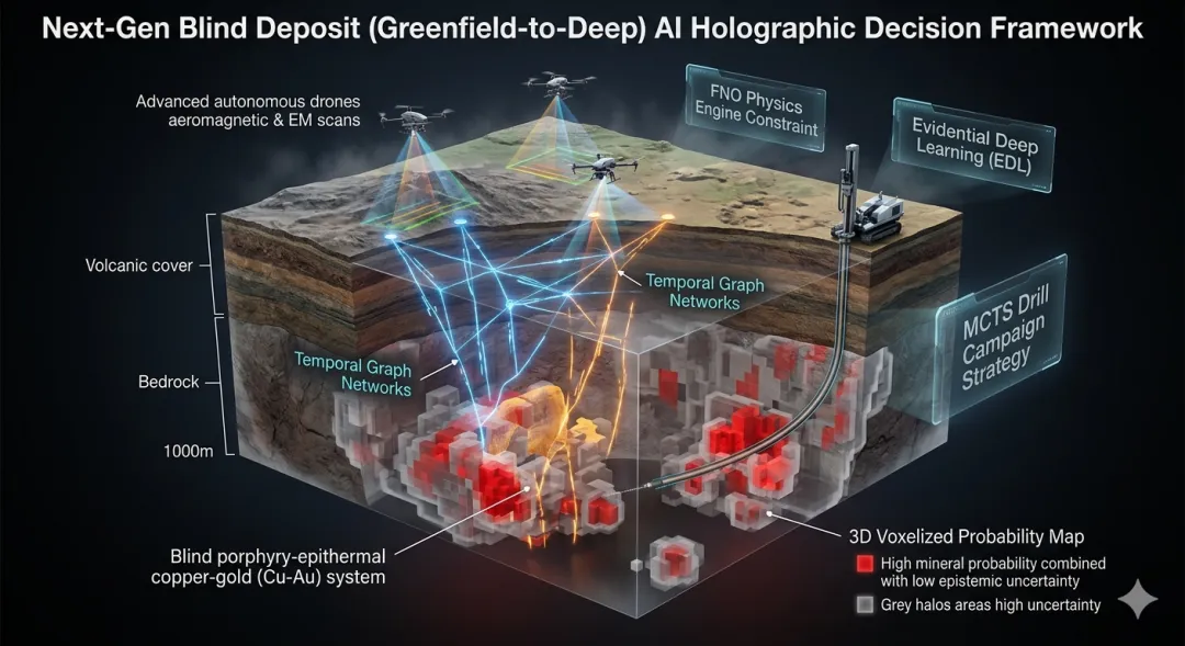
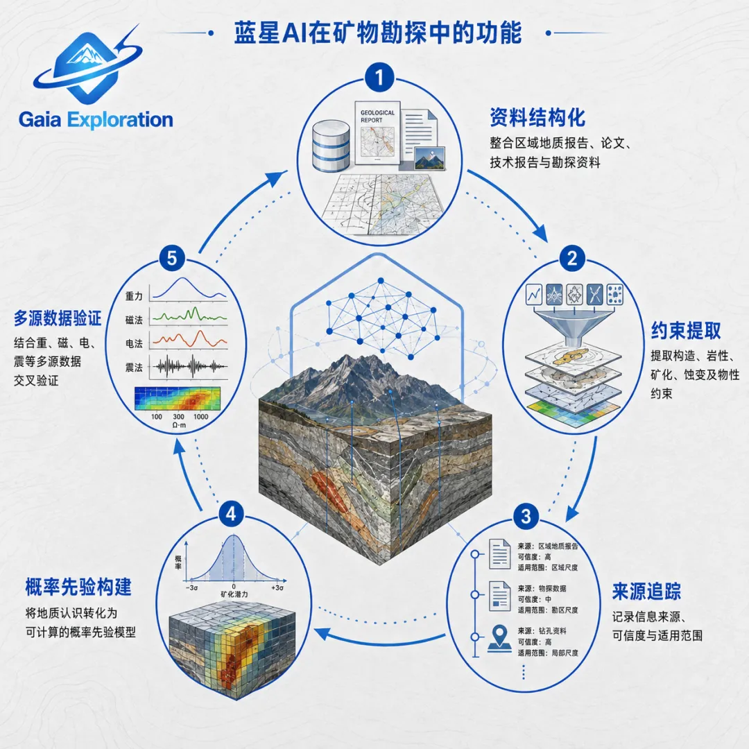
GAIA places geological, geophysical, geochemical, remote-sensing and drilling data in one interpretation framework. The purpose is not simple layer stacking. It is to connect faults, lithological contacts, alteration, anomaly associations and drill evidence into a traceable network. Traditional software calculates spatial continuity; AI can attempt to learn why continuity follows some geological paths and not others.
Overprinting demands causal interpretation
Real deposits rarely resemble clean textbook sections. Multiple magmatic and hydrothermal events, deformation, uplift, erosion, later fluid modification and weathering may be recorded in one sample. Strong As-Sb-Hg at surface may not correspond to the expected body; an obvious shallow centre may point toward a different deep centre. Overprinting and reversed zoning make anomaly detection insufficient.
AI may help move the question from where an anomaly is to how it formed. Variational autoencoders, independent component analysis and related methods can explore whether mixed multielement signals contain several latent endmembers. The analogy is separating possible ingredients in a blended drink, although geological systems are far more complicated.
Any decomposition remains a hypothesis. It cannot equal a metallogenic conclusion or replace geological constraints, field checks and drilling. The useful output is a set of causal alternatives that can be tested.
Multimodal data open the mineral record
Whole-rock geochemistry expresses a sample as concentrations of Au, Cu, Mo, As, Sb, W, Bi and other elements. It is powerful, but it averages signals from different stages. The core, mantle and rim of one pyrite grain may record different pressure-temperature conditions and fluid events that disappear in the whole-rock average.
LA-ICP-MS mineral-scale analysis, TIMA or QEMSCAN automated mineralogy, core imagery and high-resolution remote sensing now provide whole-rock chemistry, mineral chemistry, texture, core-rim zoning, alteration association and spatial location at several scales. This is why multimodal AI matters. It is not about putting more files in one system, but aligning data at different scales within the same coordinate frame and geological logic: regional structure indicates pathways; geophysics records physical contrast; geochemistry shows element migration; mineral chemistry records hydrothermal evolution; drilling provides the final constraint.
Multimodal fusion succeeds only when cross-scale evidence addresses the same explainable geological question. GAIA uses this principle to generate target priorities, confidence, evidence chains and verification paths.
Dynamic weighting depends on human-machine collaboration
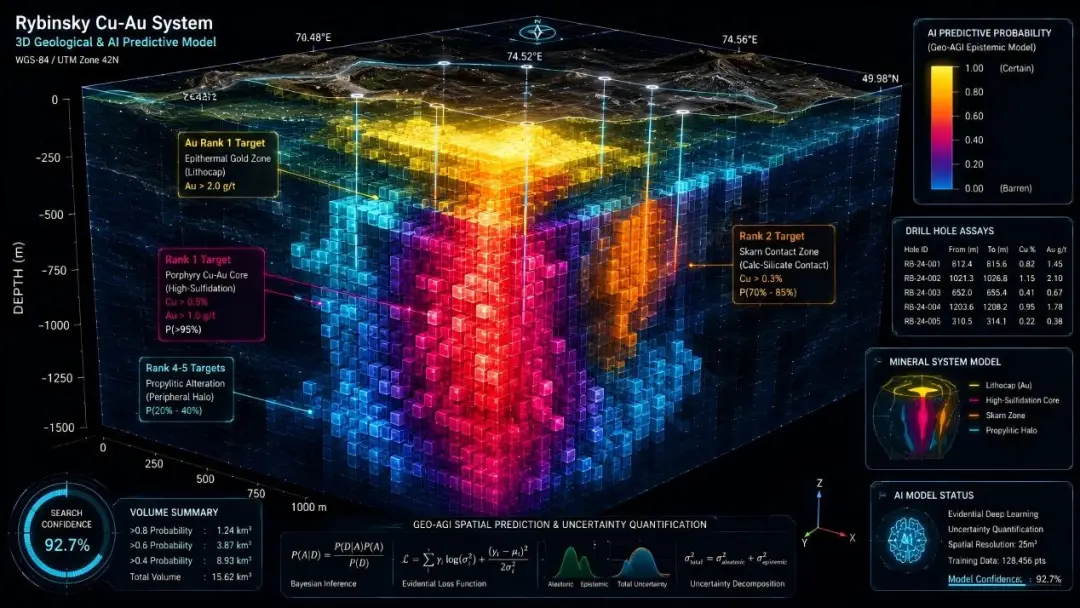
Multimodality asks where evidence comes from; dynamic weighting asks which evidence matters most. In exploration, the important meaning of Transformer attention is that a model can vary its focus with geological setting instead of relying on one fixed index weight.
High-temperature W-Mo-Bi signals may matter more in a deeply eroded terrane. Subtle volatile anomalies may deserve greater attention under thick cover. Elsewhere, structural pathways and lithological contacts may dominate over any single element. AI can adjust evidence weight to context, but must remain geologically constrained.
GAIA uses a human-in-the-loop approach. AI examines many variables and possible associations; geologists determine whether those associations agree with mineral-system knowledge and which inferences deserve field testing. AI expands the efficiency of the search, while specialists protect the causal logic and validation direction.
AI works upstream of decisions; it does not replace modelling
It is a mistake to view exploration AI as a more advanced interpolation method. If random forests merely replace kriging, the industry workflow changes little. The more meaningful use is to build a joint representation across geology, remote sensing, geochemistry, geophysics, drilling, mineral chemistry, core imagery and historical records; propose several possible explanations; and attach confidence and uncertainty to each.
The same anomaly may represent a small independent shallow body, a distal response to a deeper system or an artefact of later fluid overprinting. AI can organize these alternatives, state the evidence each one has or lacks, and identify the next data needed.
Traditional software remains essential. A practical division of labour is: AI assists multisource synthesis and target ranking upstream; senior geologists review the mineral-system logic; Leapfrog, Vulcan, Datamine or other specialist tools then support detailed 3D modelling, resource estimation and engineering design; new drilling and field data feed back to update the interpretation.
Testability determines the value of exploration AI
A beautiful prospectivity map without field, engineering or drill constraints cannot be described as an ore discovery. A prediction is a prediction, a target is a target and an anomaly is an anomaly. Their value comes from verification, not colour.
A mature model should face rigorous testing. In a well-drilled deposit, later holes can be hidden, the model given only early data, and its predictions compared with the unblinded results. The goal is not for AI to defeat the geologist. The more useful benchmark is whether geologist plus AI outperforms either one alone.
GAIA requires output to be explainable, traceable and testable, and returns field and new drilling results to the analysis. Exploration AI should be a professional process that evolves with evidence, not a one-off map.
Conclusion: from geological computation to geological intelligence
Digital geological software has spent decades answering how to calculate and model faster and more accurately. Exploration AI may help answer a different question: when evidence is incomplete, ambiguous or contradictory, which explanation deserves priority, and which next dataset will reduce uncertainty most effectively?
The maturity of traditional software and the rise of AI are not contradictory. One represents geological computation; the other is beginning to support geological intelligence. The strongest future geologist will not be the person who knows the most software buttons, nor the person displaced by AI, but the person who can translate mineral-system knowledge into model constraints and use AI to examine several alternatives at once.
As computation enters geological judgment, the scarce capability remains the ability to ask the right geological question.